The sub-areas are highlighted in colour on the map according to the type of host rock and can be shown or hidden (by clicking on the eye symbol). If you deactivate the eye at the top for the overall map, you can then display the individual sub-areas one by one. For further information on a sub-area, simply click on the respective area. After a short loading time, an information window will appear.

Sub-areas Interim Report
The Sub-areas Interim Report is the first milestone on the way to a repository for high-level radioactive waste in Germany. The basis is formed by data on the deep geological underground. 1.040,605 files have reached the Federal Company for Radioactive Waste Disposal (BGE) from federal and state authorities by the data cut-off date 1 June 2020 and have been processed in the Sub-areas Interim Report. These data come from mining, oil, or gas production as well as geothermal drilling. The BGE published the Sub-areas Interim Report on 28 September 2020 and submitted it to the Federal Office for the Safety of Nuclear Waste Management (BASE) (external link).
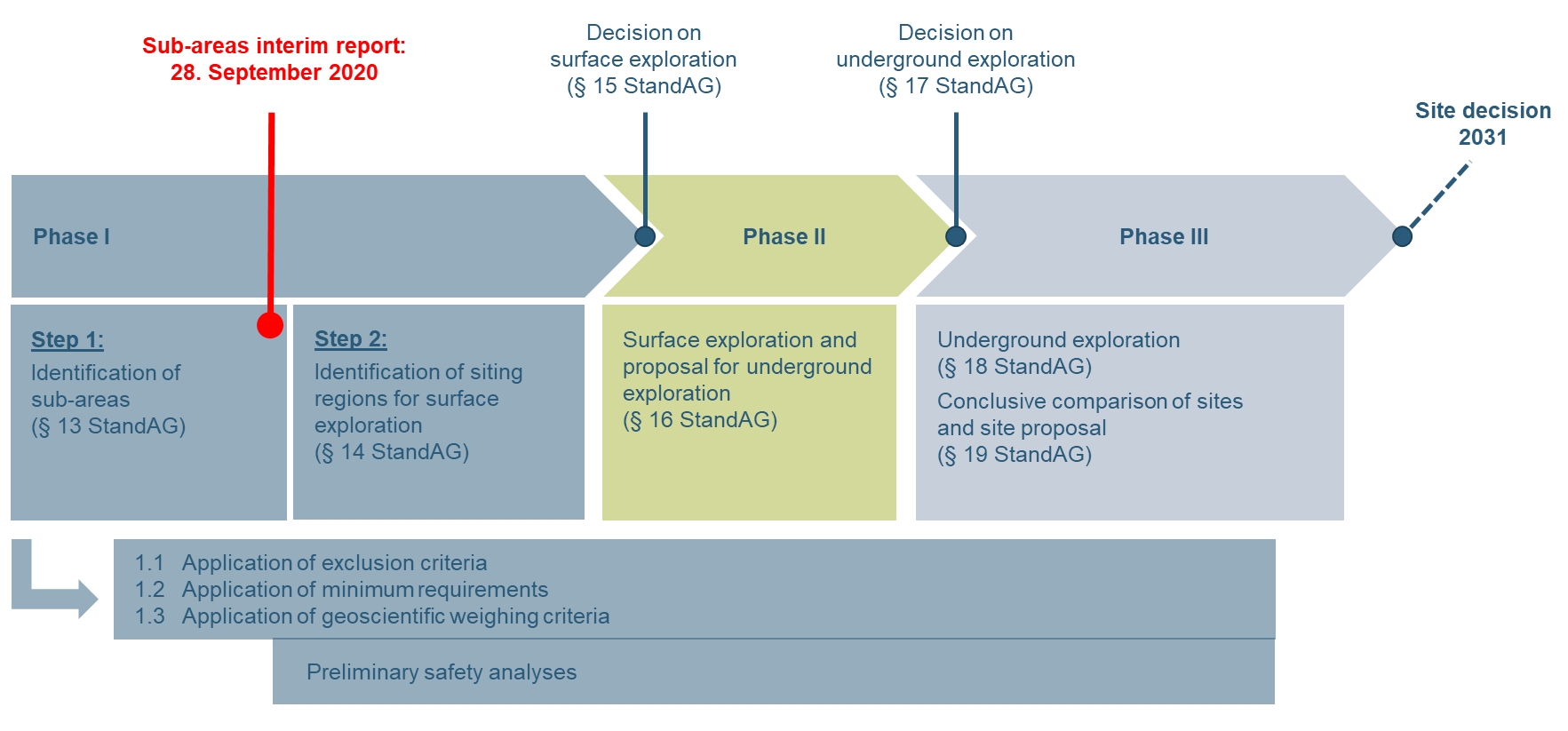
The report represents an interim status of the work of the BGE and serves as a basis for public participation before facts are established. This will be the case for the first time at the end of the next step in which the BGE makes proposals for siting regions to be explored above ground and in which the federal legislature will make a decision based on these proposals.
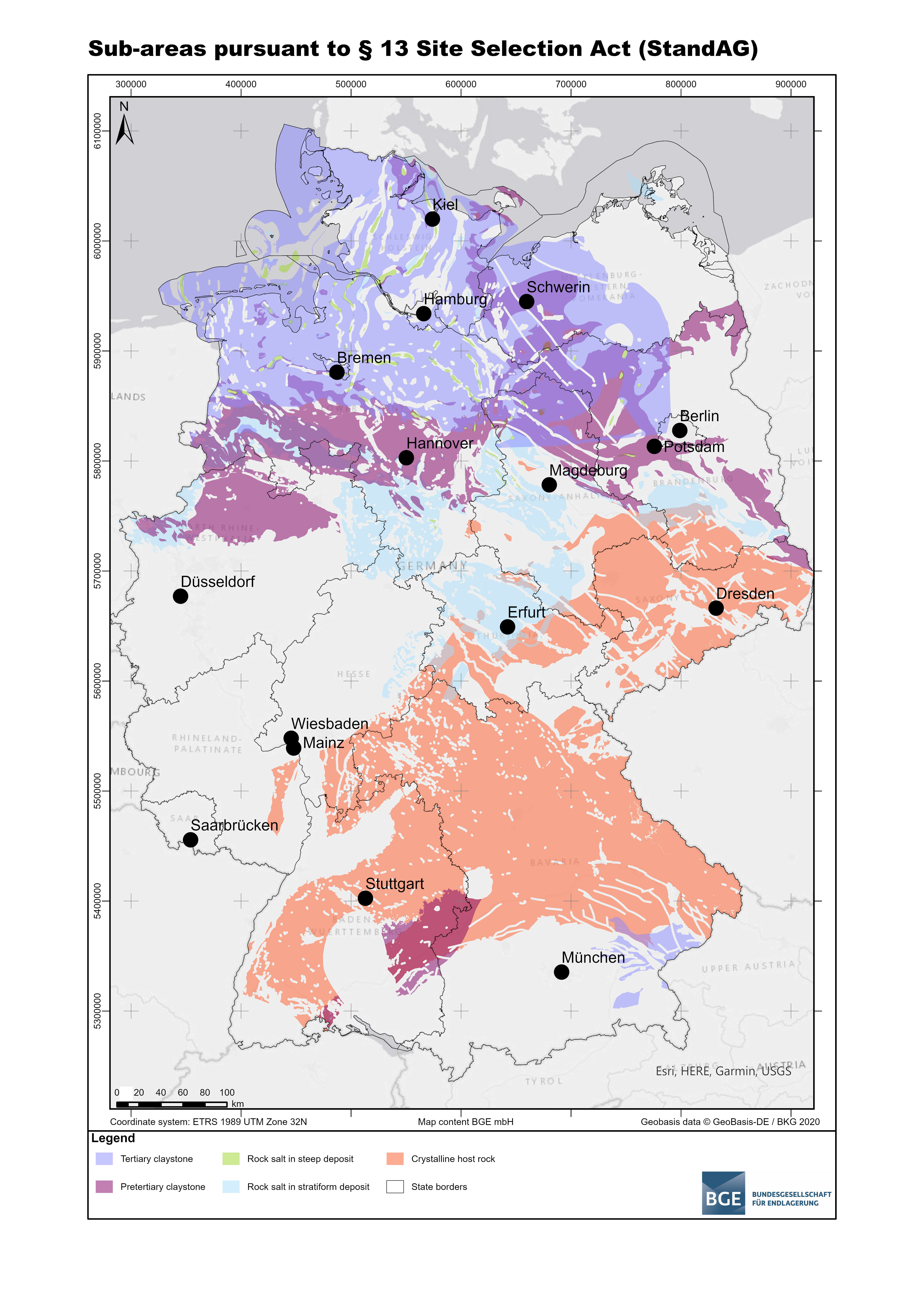
The white map from the beginning of the site selection procedure is thus becoming more colourful. This is because the Sub-areas Interim Report shows which areas in Germany can already be excluded from the repository search. And it identifies areas that will be examined in more detail in the further procedure – the 90 sub-areas.
What are sub-areas in the context of the repository search?
In accordance with the Repository Site Selection Act (StandAG), sub-areas are areas in which favourable geological conditions for the safe final disposal of high-level radioactive waste can be expected. In order to identify these areas, the BGE has applied the exclusion criteria, minimum requirements and geoscientific weighing criteria defined in the Repository Site Selection Act with the help of the available data.
The exact procedure adopted by the BGE is explained in the “supporting documents”. In addition, more-detailed data reports provide an insight into the underlying set of data. The Interim Report is based exclusively on geological criteria. Spatial planning aspects, such as the distance from residential development or proximity to nature conservation areas, only play a part in subsequent steps.
“It’s important to note that the Sub-areas Interim Report is not the final result, but rather a first intermediate stage of the process,” said Steffen Kanitz, former managing director of the BGE with responsibility for the area of repository site selection. “Citizens should receive comprehensive insights into our work before facts are established.” The publication of the Interim Report also signalled the beginning of the first legally prescribed participation format – the Sub-Areas Conference – and therefore opened up further opportunities to influence decision-making.
What happens after the publication of the Sub-areas Interim Report?
The opening event of the Sub-Areas Conference (external link) on 17 and 18 October 2020 was one of various opportunities for the BGE to present and explain its results publicly. The organizer of the event and of the ensuing events in February, April and June 2021 was the BASE, acting in its capacity as a vehicle for public participation and as a service provider for the Sub-Areas Conference. The conference organized itself.
The aim of the BGE is to create traceability and maximum transparency. In addition, citizens can provide advice, suggestions and comments that can then influence the further work of the BGE and the proposal regarding siting regions for surface exploration. The final decision as to which areas these are will be made by the federal legislature at the end of the first phase of the search procedure.