Operational geomechanical monitoring in Morsleben
The Morsleben repository is monitored from various different perspectives, including radiation protection, physical security and operational geomechanical monitoring. Geomechanics is the mechanics of the earth – that is, the science of how the ground and rocks behave in response to changes in stress or temperature, for example. It can be used to evaluate the stability of cavities – which is important when it comes to monitoring the safety of a deep geological repository.
The Morsleben repository is stable. But how do we know that?
The state of the repository mine has been recorded and monitored since 1970, and the permanent operating licence of 1986 includes a programme for the preservation of evidence and monitoring. The instructions for different operating sections set out precisely how the monitoring measures are to be implemented. There are also binding rules regarding documentation: every change in the mechanical behaviour of the rock must be recorded. This allows experts to evaluate the operational and long-term safety of the Morsleben repository.
What does the monitoring programme look like?
Specifically, the geomechanical monitoring of the mine cavities consists of a seven-part programme. This must be carried out regularly by the members of the mine surveying team, working in collaboration with colleagues from the geoinformation team. The staff need all individual results from the monitoring programme to be able to issue a reliable overall evaluation of stability.
- Height monitoring above ground
Above ground in the vicinity of the Morsleben repository, there are around 300 reference points that are regularly checked by mine surveyors for height changes at ground level. The survey network covers an area of 35 square kilometres and comes to a total length of just under 93 kilometres. The mine surveyors compare the results of their regular measurements in order to draw conclusions regarding movements of the ground. In Morsleben, the rate of movement has been so low for decades that it was possible to define a change in the monitoring cycle in 2020 – in the future, the full height network will only be monitored every four years. In the meantime, the mine surveyors will measure a smaller network every second year. This network only covers the area in which the largest movements are known to take place. The results will be precisely documented and incorporated into the mine plans of the Morsleben repository. - Height monitoring underground
There is also an underground height network in the mine cavities of the Morsleben repository. This network is made up of around 860 height reference points, which are located on the ceilings of the mine cavities – known as the roofs. For the purpose of height monitoring, experts in operational geomechanical monitoring take measurements with a very high degree of accuracy. Height differences between two measurement points are measured down to the millimetre range in a technique known as precise levelling – in this case, using fixed measurement points attached to the roof. The full levelling process takes the mine surveyors around two months every year. The data is then evaluated and checked for potential changes. Comparing the results with those of the previous year allows conclusions to be drawn about vertical rock movements. - Convergence measurements
In order to measure convergence, an instrument is used to measure the distance between two opposite points at a fixed measurement station. The actual measurement points are anchored at a depth of some 80 centimetres within the rock in the mine cavities. In general, the convergence measurement stations consist of one horizontal and one vertical metering installation. If the distances between the metering installations decreases, this is referred to as “convergence”. Deformation of workings is normal in salt mining. Salt can undergo plastic deformation at low speed under the pressure exerted by the surrounding rock. In Morsleben, this rate of deformation is generally less than two millimetres per year – without the formation of cracks or other such faults. Here, the mine surveyors take convergence measurements at least twice a year at around 290 stations. - Extensometer measurements
Extensometers provide mine surveyors with an indication of deformation within the rock. To take these measurements, miners create boreholes in the rock, into which they anchor the extensometers. These instruments then measure the displacement between their anchor points at various depths within the borehole. There are around 80 extensometers in active use in the Morsleben repository mine, producing measurements with a very high level of accuracy. Depending on the type of device, the results are accurate to as little as 0.1 millimetres. With most of the instruments, the measurements are recorded automatically every six hours. - Fissurometer measurements
Fissurometers are installed at a total of 15 points in the Morsleben mine cavities. These instruments, which are attached at the surface of a crack, measure even the smallest changes in fracture widths in the three spatial directions. The results are on the scale of millimetres over the course of a year, but they are nevertheless of scientific importance as they offer greater insights into the development of crack formation. Depending on the location, the fissurometer measurements are evaluated on a monthly or six-monthly basis. - Microacoustics
Geophones – microphones developed specially for geology – record the seismic energy in the high-frequency range between 1 and 100 kilohertz. With the help of special software, these measurements can even be used to detect and locate the formation of a microfissure. In this way, experts can draw conclusions regarding the intactness of the rock and the stability of cavities in the mine. The accurate interpretation of microacoustic measurements is also reliant on the results of other geomechanical examination methods for the purposes of mutual calibration. Among others, these methods include model calculations and laboratory analyses. Here, the BGE is supported by external institutions, such as the Federal Institute for Geosciences and Natural Resources (BGR). - Seismic positioning
Seismic positioning is used to locate seismic events, such as tremors due to the formation of a fissure or the breaking away of lumps of rock. Morsleben features an extensive underground monitoring network for this purpose. The received data can be used to determine the position and characteristics of an event. Due to the sensitivity of the instruments, they also detect global events such as earthquakes.
Operational geomechanical monitoring prevents hazards
Even before some 4,000 tonnes of rock broke away in a mining chamber in the central part in 2001, microacoustic measurements had already provided evidence not only of the loosening of the rock salt in the central part of the mine, but also of localised crack formation at the boundary between rock salt and anhydrite. To protect staff, the central part was therefore closed off so that no more work could be carried out there. Since 2011, stability has been restored thanks to the measure referred to as “prevention of mining hazards in the central part”.
All quiet in Morsleben
Barely any changes can be detected at most measurement points. Overall, the rock is moving at a rate of less than one millimetre per year. Slight changes occur in a very uniform manner, and all measurements show that the repository is safe for mining operations.
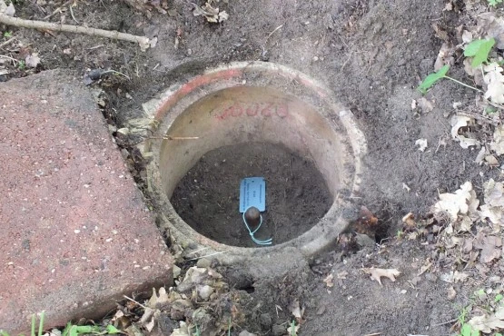
Ground movements are monitored at the surface using around 300 height reference points over an area of 35 km²

A convergence meter is clamped between two reference points to examine changes in distance
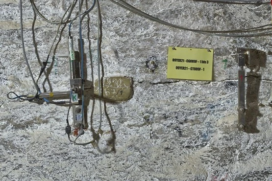
Two fissurometers are used to monitor a horizontal crack in the salt rock
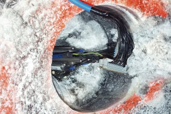
A multi-point extensometer has been anchored in a borehole in order to monitor a supporting pillar in the mine cavities

